As we all know from geography, the Russian Federation is the largest country in the world by area (17,425.2 thousand km2, 85 subjects). Many territorial units of our state, in turn, are larger than some world countries. What are the sizes of the largest regions in Russia - subjects of the Russian Federation by area - we will tell below.
| # | Subject of Russia | Area, km² | % from RF |
|---|---|---|---|
| 1 | Republic of Sakha (Yakutia) | 3083523 | 18.01 |
| 2 | Krasnoyarsk region | 2366797 | 13.82 |
| Tyumen region with Khanty-Mansiysk and Yamalo-Nenets Autonomous Okrugs | 1464173 | 8.55 | |
| 3 | Khabarovsk Krai | 787633 | 4.6 |
| 4 | Irkutsk region | 774846 | 4.52 |
| 5 | YANAO | 769250 | 4.49 |
| 6 | Chukotka Autonomous Okrug | 721481 | 4.21 |
| Arkhangelsk region including NAO | 589913 | 3.44 | |
| 7 | Khanty-Mansiysk Autonomous Okrug - Yugra | 534801 | 3.12 |
| 8 | Kamchatka Krai | 464275 | 2.71 |
| 9 | Magadan region | 462464 | 2.7 |
| 10 | Transbaikal Territory | 431892 | 2.52 |
| 11 | Komi Republic | 416774 | 2.43 |
| 12 | Arkhangelsk region without NAO | 413103 | 2.41 |
| 13 | Amur region | 361908 | 2.11 |
| 14 | Republic of Buryatia | 351334 | 2.05 |
| 15 | Tomsk region | 314391 | 1.84 |
| 16 | Sverdlovsk region | 194307 | 1.13 |
| 17 | Republic of Karelia | 180520 | 1.05 |
| 18 | Novosibirsk region | 177756 | 1.04 |
| 19 | Nenets Autonomous Okrug | 176810 | 1.03 |
| 20 | Republic of Tuva | 168604 | 0.98 |
| 21 | Altai region | 167996 | 0.98 |
| 22 | Primorsky Krai | 164673 | 0.96 |
| 23 | Perm region | 160236 | 0.94 |
| 24 | Tyumen region without Khanty-Mansiysk and Yamalo-Nenets Autonomous Okrugs | 160122 | 0.94 |
| 25 | Murmansk region | 144902 | 0.85 |
| 26 | Vologda region | 144527 | 0.84 |
| 27 | Republic of Bashkortostan | 142947 | 0.83 |
| 28 | Omsk region | 141140 | 0.82 |
| 29 | Orenburg region | 123702 | 0.72 |
| 30 | Kirov region | 120374 | 0.7 |
| 31 | Volgograd region | 112877 | 0.66 |
| 32 | Saratov region | 101240 | 0.59 |
| 33 | Rostov region | 100967 | 0.59 |
| 34 | Kemerovo region | 95725 | 0.56 |
| 35 | Altai Republic | 92903 | 0.54 |
| 36 | Chelyabinsk region | 88529 | 0.52 |
| 37 | Sakhalin region | 87101 | 0.51 |
| 38 | Tver region | 84201 | 0.49 |
| 39 | Leningrad region | 83908 | 0.49 |
| 40 | Nizhny Novgorod region | 76624 | 0.45 |
| 41 | Krasnodar region | 75485 | 0.44 |
| 42 | Republic of Kalmykia | 74731 | 0.44 |
| 43 | Kurgan region | 71488 | 0.42 |
| 44 | Republic of Tatarstan | 67847 | 0.4 |
| 45 | Stavropol Krai | 66160 | 0.39 |
| 46 | Republic of Khakassia | 61569 | 0.36 |
| 47 | Kostroma region | 60211 | 0.35 |
| 48 | Pskov region | 55399 | 0.32 |
| 49 | Novgorod region | 54501 | 0.32 |
| 50 | Samara region | 53565 | 0.31 |
| 51 | Voronezh region | 52216 | 0.3 |
| 52 | Republic of Dagestan | 50270 | 0.29 |
| 53 | Smolensk region | 49779 | 0.29 |
| 54 | Astrakhan region | 49024 | 0.29 |
| 55 | Moscow region | 44329 | 0.26 |
| 56 | Penza region | 43352 | 0.25 |
| 57 | Udmurt Republic | 42061 | 0.25 |
| 58 | Ryazan region | 39605 | 0.23 |
| 59 | Ulyanovsk region | 37181 | 0.22 |
| 60 | Jewish Autonomous Region | 36271 | 0.21 |
| 61 | Yaroslavl region | 36177 | 0.21 |
| 62 | Bryansk region | 34857 | 0.2 |
| 63 | Tambov region | 34462 | 0.2 |
| 64 | Kursk region | 29997 | 0.18 |
| 65 | Kaluga region | 29777 | 0.17 |
| 66 | Vladimir region | 29084 | 0.17 |
| 67 | Belgorod region | 27134 | 0.16 |
| 68 | Republic of Mordovia | 26128 | 0.15 |
| 69 | Republic of Crimea | 26081 | 0.15 |
| 70 | Tula region | 25679 | 0.15 |
| 71 | Oryol region | 24652 | 0.14 |
| 72 | Lipetsk region | 24047 | 0.14 |
| 73 | Republic of Mari El | 23375 | 0.14 |
| 74 | Ivanovo region | 21437 | 0.13 |
| 75 | Chuvash Republic | 18343 | 0.11 |
| 76 | Chechen Republic | 16165 | 0.09 |
| 77 | Kaliningrad region | 15125 | 0.09 |
| 78 | Karachay-Cherkessia | 14277 | 0.08 |
| 79 | Kabardino-Balkaria | 12470 | 0.07 |
| 80 | Republic of North Ossetia-Alania | 7987 | 0.05 |
| 81 | Republic of Adygea | 7792 | 0.05 |
| 82 | Republic of Ingushetia | 3628 | 0.02 |
| 83 | Moscow | 2561 | 0.01 |
| 84 | Saint Petersburg | 1403 | 0.01 |
| 85 | Sevastopol | 864 | 0.01 |
10. Kamchatka Krai, S = 464,275 km²
 Situated in the north-east of the country, on the Kamchatka Peninsula (Far Eastern Federal District), it is washed by the waters of the Pacific Ocean, as well as the Sea of Okhotsk and the Bering Sea. One of the most beautiful regions of Russia - there is a valley of geysers with thermal and mineral springs, and active volcanoes (there are about 30 of them). All of the above, together with the combination of natural untouched beauty of the tundra and alpine meadows, makes this area popular among tourists.
The Kamchatka Peninsula is sparsely populated – only about 315 thousand people live on a large area – this is largely due to unfavorable, unstable natural conditions. Perhaps this is why the ecological situation in Kamchatka is one of the most favorable in the Russian Federation.
The region occupies a leading position among other regions of Russia in terms of the volume of precious metals (gold and platinum) production, and is distinguished by its rich marine bioresources (industrial fishing of commercial fish, seafood, and Kamchatka crabs has been established on the peninsula).
For comparison: Kamchatka Krai is larger in area than England, Belgium, Portugal and Luxembourg.
9. Khanty-Mansiysk Autonomous Okrug - Yugra, S = 534,800 km²
 The region is located in the central part of the West Siberian Plain (part of the Ural Federal District); it is rich in water resources, taiga forests, and large navigable rivers (Ob, Irtysh). The highest point of the Ural Range, Mount Narodnaya (1895 m), is located in this region. The territory, although vast, is sparsely populated (density of 3.1 people per sq. km). The indigenous population – the Khanty and Mansi – make up only 2% of the total number of nationalities.
Oil and gas are extracted in the district – Khanty-Mansiysk Autonomous Okrug is the largest supplier of “black gold” to the Russian Federation, therefore the main specialization of industrial enterprises is servicing the oil and gas production industry. The logging complex is also developed.
All this has allowed the region to become one of the best in the country in terms of quality of life.
Due to the favorable economic situation, the population of Yugra is steadily increasing: 1,558 thousand people were recorded in 2012, 1,626.8 thousand people in 2016.
8. Arkhangelsk region, S = 589,913 km²
 The subject is located in the northwest of the country, part of the land belongs to the regions of the Far North. The region, which among other Russian subjects is the leader in the total area of islands (104.4 thousand sq. km), includes the Franz Josef Land and Novaya Zemlya Archipelagos. The northernmost point of Russia, Europe and the entire continent is also located here - Cape Fligely. It is washed by the northern seas - the White, Barents and Kara. In its size it exceeds the territory of France, Spain, Madagascar.
The region is fabulously rich in natural resources: an abundance of oil, gas, timber, diamonds, bauxite, gypsum, gold and other metals makes this region one of the key mineral extraction regions in Russia, and the wild beauty of the northern lands and thousands of lakes makes it one of the most beautiful.
The autonomous district is an industrial region: the territory of the subject of the Russian Federation includes the Plesetsk cosmodrome, as well as defense industry enterprises in Severodvinsk (production of nuclear submarines), pulp and wood production, shipbuilding and the fishing industry are well developed. The population is 1,155,028 people (as of 01.01.2018).
7. Chukotka Autonomous Okrug, area 721,481 km²
 The least populated subject (population density of only 0.07 people/km²), number of residents – 49,348 people (as of January 1, 2018).
Geographically located in the extreme north-east of the Russian Federation, on the shores of the Arctic Ocean and partly the Pacific Ocean. The autonomous district is located on the Chukotka Peninsula, small islands and part of the mainland, belongs to the Far Eastern Federal District. The border with the United States runs along the Bering Sea.
Due to its difficult geographical location (halfway beyond the Arctic Circle), it combines subarctic, maritime and continental climates. Winter here lasts 10 months a year. The basis of the life of the indigenous peoples (Chukchi - 25%, Eskimos - 3%) is reindeer herding, hunting and fishing.
Large deposits of gold, arsenic, silver, tin, and mercury were found in the depths of the Chukotka Autonomous Okrug.
6. Yamalo-Nenets Autonomous Okrug, S = 769,250 km²
 The largest autonomous district of Russia, translated from the Nenets language, is the Edge of the Earth. It is located in the northwest Asian part of Russia. It occupies one of the largest plains – the West Siberian. The capital of the district – Salekhard – is located on the Arctic Circle – half of the city is already located in the Arctic. A significant part of the territory is the Yamal Peninsula.
Since ancient times, the district has been a supplier of fish, furs and venison. The main income of the region is now formed by the sale of extracted oil, gas, venison and fish. In terms of combustible gas reserves, this region ranks first, and in terms of oil reserves - second, and is also rich in other minerals, such as manganese, chromium, copper, pigs, cobalt, nickel, etc.
The population is only 538,547 people (according to 2018 data), according to experts, the demographic situation in Russia as a whole is not bad due to the influx of young people and the dynamic development of the gas production industry.
5. Irkutsk region, S = 774,846 km²
 The region is located in the south of Eastern Siberia. The main attraction is Lake Baikal. The largest rivers on the geographical map of our vast homeland flow through the Irkutsk region - Angara, Lena, Yenisei, and the main attraction of the region is Lake Baikal.
Among other Russian territorial units, the Irkutsk region is also considered a "rich" land - gold (Lena gold-bearing region), iron, coal, iron ore, hydrocarbons, manganese ores, rare metals - in general, a large number of useful minerals are mined here. The nature of the region is also rich in its forests - 11.5% of all forests in Russia are concentrated here.
The territory is part of the East Siberian Economic Region. The main production sectors are the extraction of mineral resources, power generation, mechanical engineering (construction of Su-30 aircraft), and the production of cellulose and wood. The region occupies a leading position in the Russian Federation in the extraction of furs.
As of January 1, 2018, the population was 2,404,195.
4. Khabarovsk Krai, S = 787,633 km²
 It occupies the central part of the Far East, washed by the Sea of Okhotsk and the Sea of Japan in the east. The southwestern borders run along the state border with China. Due to the large extent of the land and the elongated shape, there is a diverse climate and relief: from the tundra and taiga to the mountain ranges of the Sikhote-Alin. About 80% of the entire territory is occupied by mountains. Here you can meet the Amur tiger, snow leopard, brown bear or leatherback turtle, and in the largest Far Eastern river Amur - there are rare species of fish, for example, the Amur sturgeon.
The region is notable for its reserves of precious and non-ferrous metal ores (gold, platinum, silver, tungsten, copper), and significant reserves of precious and semi-precious stones. The federal subject accounts for 100% of Russian tin production, and is also engaged in primary oil refining and timber production (8th place in the Russian Federation).
It is noteworthy that there are few roads in the Khabarovsk Territory, so communication with the mainland is carried out mainly by air transport and railways (the Trans-Siberian and Baikal-Amur Railways run through the territory).
The population is 1,328 thousand people (2018) and is distributed extremely unevenly across the territory - mainly in the area of large cities (Khabarovsk, Komsomolsk-on-Amur, Amursk).
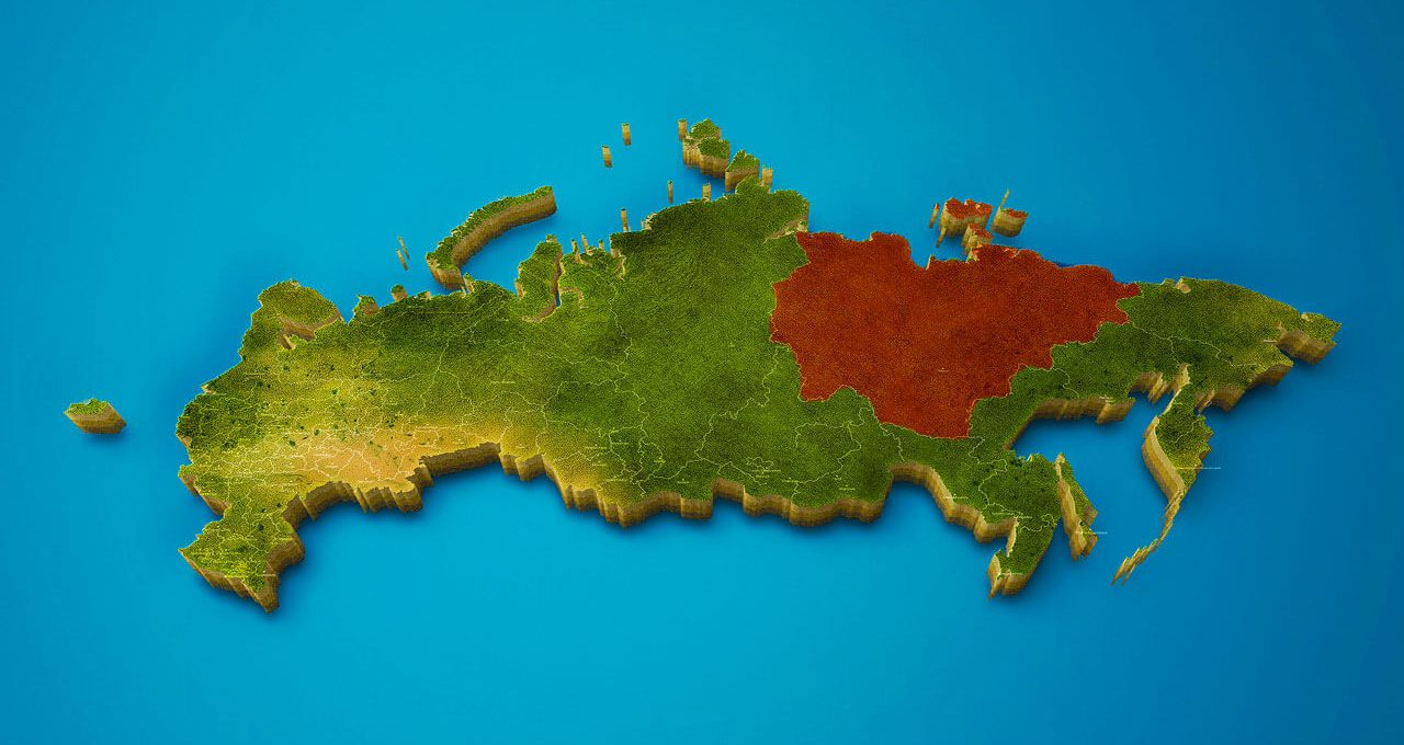
3. Tyumen region, S = 1,435,200 km²
 The largest region in Russia lies in the west of the Asian part of the Russian Federation (southwest of the West Siberian Plain), in the south the subject borders with Kazakhstan. It occupies 8.55% of the area of the Russian Federation. The population is gradually increasing, due to migration growth: if in 2012 it was 3,453.69 thousand people, then in 2018 - 3,692,400 people.
One of the world's largest oil and gas complexes was founded in the Tyumen region, the deposit of which was discovered in 1964 (estimated at up to 200-230 million tons of recoverable oil). Before that, the region was mainly engaged in agriculture. Most of the industry now falls on manufacturing (oil products, petrochemicals, chemical industry), production of building materials, logging. The region is also famous for the quality of medical care.
Large rivers include the Irtysh with its tributaries the Tobol and Ishim, rich in fish, and most of the plains are occupied by swamps.
2. Krasnoyarsk Krai, S = 2,366,797 km²
 The region, which is part of the Siberian Federal District, is located in Eastern Siberia, in the Yenisei River basin, with a lowland to the left and the Central Siberian Plateau to the right. The region is washed by the Kara Sea and the Laptev Sea from the north. It includes several archipelagos and smaller islands. The northernmost point of Eurasia, Cape Chelyuskin on the Taimyr Peninsula, is located within the Krasnoyarsk Territory.
In total, the length of the territories reaches about 3000 km and occupies 13,82% of land from the entire territory of the Russian Federation.
The river and lake network is developed, there are about 323 thousand lakes, and this is more than 11% of all lakes in the country. The largest hydroelectric resources in Russia are concentrated here, and the Krasnoyarsk hydroelectric power station is one of the most powerful hydroelectric power stations in the world. The region is also provided with natural resources (platinum group metals, nickel, copper, lead, cobalt), oil and gas.
Population: 2,876 thousand people (in 2018)
1. Republic of Sakha (Yakutia), S = 3,083,523 km²
 is the largest subject of the Russian Federation") Here is the answer to the question of which subject of Russia is the largest. The Sakha Republic is the largest subject of the Russian Federation by territory, which occupies 18,01% of the area of the Russian Federation, and is part of the Far Eastern Federal District.
Here is the answer to the question of which subject of Russia is the largest. The Sakha Republic is the largest subject of the Russian Federation by territory, which occupies 18,01% of the area of the Russian Federation, and is part of the Far Eastern Federal District.
The republic stretches from the shores of the East Siberian Sea and the Laptev Sea to the Aldan Highlands (2,000 km from north to south, 2,500 km from west to east). If compared with other countries in the world, the size of Yakutia is equal to, for example, five such countries as Ukraine.
At the same time, the object is sparsely populated (958.29 thousand people) - the population density is 0.31 people / sq. km. This is mainly due to the mountainous terrain and harsh natural conditions (a third of the territory lies beyond the Arctic Circle). The famous Oymyakon is home to the cold pole of the Northern Hemisphere with a recorded minimum temperature of -68 degrees Celsius.
Here, the cultural heritage of the Yakuts, Evens and Evenki – the indigenous inhabitants of the republic – is carefully preserved.
The region is unique in the volume and potential of its natural resources: deposits of coal, hydrocarbons, gold, diamonds (25% of the world's production volume), antimony, uranium and other rare minerals have been found.


Оставить Комментарий