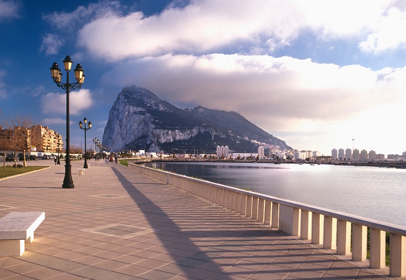
Before the discovery of America, Europe was considered the edge of the world in the West. Apart from the northern Scandinavian countries and the countries of southern Africa, there was one geographical accident that also marked the limit. It was the Rock of Gibraltar, also known as the Columns of Hercules.
Included in Greek mythology, the area around the Rock played an important role in human civilization even before 500 BC. Considered one of the most visited waterways in the world, it has a direct impact on world trade. The area connects the Atlantic Ocean in the west with the Mediterranean Sea in the east. But along the entire length of the ocean is the American continent, and numerous peoples live on the coast of the sea.
Morocco to the south and Spain to the north, surrounding the main part of the site. Apart from being an important shipping and trade route, this site has a lot to offer. Its long history has many interesting stories. There are tourist spots and famous sites, such as the impressive headland of the Rock of Gibraltar, which stands out meters from the ground. In this article, we will look at the most interesting facts about Gibraltar. From its unusual etymology to its geographical and economic importance, this is your guide to everything related to the Strait of Gibraltar.
The word "Gibraltar" comes from the Arabic phrase "Jabal al-Tariq".

One of the most prominent features of Gibraltar is the large rock that stands out in the air. The height of over 460 meters is a characteristic of the land that derives its name from Gibraltar. In Arabic, the word "Jebel" or "Jebel" means mountain. Tariq refers to a Berber commander from North Africa who once led a major military expedition to this area. The commander - Tariq ibn Ziyad - crossed the area to the cape in the early 8th century AD, and since then it has been known as "Jebel al-Tariq" or "Montagna de Tariq".
Gibraltar is the Spanish origin of the Arabic phrase, given that the region is close to the Spanish mainland. The ruler of Ceuta, now an autonomous Spanish territory, arranged for a Berber army to cross from their North African kingdoms into Spain. A large fleet of ships was used to transport them, and this marks one of the first confirmed crossings of their territory. When they landed, they fortified themselves at the foot of a rocky outcrop that was christened after the commander who led them there. Tariq and another Berber leader, Musa ibn Nusayr, later captured much of Spain with 20,000 soldiers. The port of Tarifa, west of Gibraltar, is named after Tariq ibn Ziyad, the bell of another Muslim leader named Tarif who had landed on the coast a few years earlier.
Despite its proximity to Spain, Gibraltar is a British territory.

Looking at a map of Gibraltar, it is easy to confuse it with the Spanish city. However, Gibraltar is actually a special overseas territory of Great Britain. After becoming part of Spain, it was ceded to Great Britain following the War of Succession of Española. A peace treaty signed in the Dutch city of Utrecht (known as the Treaty of Utrecht) granted Great Britain permanent rights to govern Gibraltar. However, there were numerous attempts by the Spanish to reclaim the region, including armed conquests in the 18th and 19th centuries.
Spain has claimed that it wants to reunite Gibraltar with the rest of the peninsula, and has recently been questioned at the United Nations on numerous occasions. However, the UK has consistently refuted Spain's claims. Gibraltar has held numerous referendums and public votes for citizens to choose which country they wish to join. The majority voted to remain in the UK, and in the most recent referendum, 98% voted to remain.
Today, the issue has become more pressing due to the growing importance of trade, los ingresos y lasrentas and the military significance of the area. The UN recognizes Gibraltar as an autonomous territory. Stagnation has been going on for the past three centuries, although there have been no armed clashes in the last few years. According to the UK position on the issue and international maritime law, the UK cannot directly control the passage of ships through the leg, except in cases of illegal smuggling. Although it is used legally, there are no restrictions on the use of the area by other countries, armed or merchant ships.
The Rock of Gibraltar and the North African peak together form the "Pillars of Hercules".
Gibraltar is crossed by the mythical Pillars of Hercules, which refer to the mythical Greek hero Hercules. The myth says that Hercules spent 12 labours crossing Mount Atlas to create the stretch. The pillar of the European coast is the Rock of Gibraltar, while the pillar opposite continues to be a subject of debate. The Rock of Gibraltar is known as Calpe Mons, while the opposite peak is known as Abila Mons. There are two main hills that have historically been considered the second pillar: Monte Acho (in Ceuta) and Jebel Musa (Morocco). The area was also special to the Greeks, who believed it to be the place where the titan Atlas carried the weight of the sky on his shoulders. When Hercules crossed, he is said to have written on the pillars “Non-Plus Ultra”, meaning “nothing but alla”. A Spanish shield bears this inscription, although it has now been changed to “Plus Ultra” following the discovery of America. It was important in Greek mythology as the Greeks offered their prayers to Hercules here. The Rock is also a famous tourist destination and many people come to Gibraltar for all that it has to offer.
Gibraltar is famous for its "Punta de Europa".

The waters of the Mediterranean Sea and the Atlantic Ocean could not be more different. The sea has a very high salt content, while the ocean has a milder environment for the survival of various creatures. The exact point where these two water masses meet is known as the “Punta de Europa”. Europa is the southernmost point of the Iberian Peninsula and is located in Gibraltar. The other point, Punta de Tarifa, is located further west and parallel to Punta de Europa.
The area is a famous tourist spot with notable buildings such as the Harding Battery, the Ibrahim al-Ibrahim Mesquita, the Faro de Europa and the Sikorski Monument. The Harding Battery was a British fortification built in the 19th century that could fire rockets across the site. The Ibrahim Mosque was built as a gift to the King of Saudi Arabia, Senhor Fahd bin Abdulaziz Al Saud in 1997. It serves the diverse Muslims of the region. The Faro de Europa is a famous spot from where Morocco can be seen on a clear day. Finally, the Sikorski Memorial was built in memory of the victims of the B-24 crash that took the life of Commander Wladyslaw Sikorski (the Polish Prime Minister in exile) when he crashed in Gibraltar.
There is an underground labyrinth in Gibraltar that has been involved in great wars.

Gibraltar has been the scene of countless wars since the 2nd century AD. From the Berber invasions that entered the area under its sole name to the many attempts by the Spanish to reclaim Gibraltar, the area has played an important role in the battle. One of the main reasons is the location of the tripwire. It is a step between the Atlantic Ocean and the Mediterranean Sea, one of the most popular shipping routes in the world. For this reason, the country that controls Gibraltar can blockade and prevent shipping in the event of war. Current British government laws allow any boat to sail as long as it is registered, does not carry illegal cargo without passage and respects the rules of navigation.
The land battles to conquer Gibraltar left many enduring features in the area. From Harding’s Battery at Punta de Europa to the maze of tunnels beneath the surface, there are several attractions for history buffs. These tunnels were built by the British during the American Revolutionary War. When French and Spanish forces attacked the area, the British fired their long-range guns to the south. This resulted in a series of tunnels that could be used to secretly and safely transport messages and troops across the island. Today, visitors to the island can tour most sections of the tunnel, which are open to the public.


Оставить Комментарий